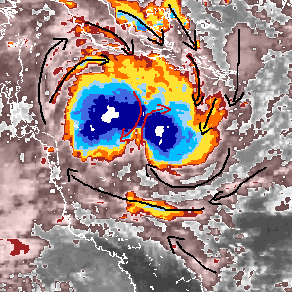
Where could be the storm-center?
-
 by
Struck
moderator, translator
I wish you a beautiful monday scientiest and civilian scientist of CycloneCenter,
the storm-image, which we can see in the right corner of this topic, looks amazing and was classified by the CycloneCenter Member 'bretarn'.
In the detailed classification of CycloneCenter, often you get the question about the location of the storm-center, but also often, we have some unusual storm-pictures, where the search for the location of the storm-center could be very difficult.
One of these cases can we find here.
In this topic, feel free to discuss and offer your ideas to this picture, where the storm-center could be.
We are looking forward to your answers. : - )
Posted
-
 by
Struck
moderator, translator
Personally I would like to make a first analysing-try, too.
I must admit, that I had thought about an analyises method for a long time.At first I ask myself, which elements and features can we find in this picture:
- Two round blue/darkblue storm-areas in the East and West of the storm
- Every darkblue circle has a white small round area in the center of his darkblue area
- The pink and grey 'lines' on the right side of the storm have a 90° and 180° form, which could stand for a clockwise-rotation
- Very impressive and dominant is the 'restricted' edge form in the South of the storm
With these notes, I made two theses for myself:
1) The storm-picture shows us two-cells (embedded-centers) and two storm-centers
2) The storm-picture shows us one 'embedded-center' system with only a single storm-centerAnnotations to this picture (left click):
"Restricted edge form, which could seperate the storm into two embedded-centers with two storm-centers":(65x60@266,245)"The first darkblue round area with a white area in the center":(97x78@199,182)
"The second darkblue area, also with a white area in his center":(60x50@245,299)
"This grey/pink line could stand for a clock-wise rotation":(196x86@342,402)
"A grey/pink line with a 180° form, which could stand for a clockwise rotation":(168x35@350,312)
The next question was, how we can get an overview about the whole rotation of the storm-picture (clockwise or anticlockwise), because I wasn't sure about the wind-routes.
So I made a try to create a sequence with a few storm-pictures:

In my point of view it looks like a clockwise-rotation, so with this information I made the next try to find out the wind routes in a next step:

The red arrows in the middle of this storm-formation show us a very interesting case and they have different directions to eatch other.
Finally I come to the conclusion, this storm-picture could show us two 'embedded-centers' with two seperated storm-centers in the white areas (thesis 1).
Also the 'restricted' edge was a dominant feature in the South, which could support the thesis 1, too.
But, I said it at the beginning of the analysis, this storm-picture is very hard to determine, so I could be on the wrong way, too. ; - )
Posted
-
 by
bretarn
translator
What a job you made! I also think about two embedded centers with two separate centers, we can see later the western center melting away while the eastern stay active , evolving toward a center for a Curved-band storm spinning clockwise. Thanks a lot for this analysis full of teaching for a pure "amateur" like me.
Posted
-
 by
Struck
moderator, translator
Special thank you for your comment bretarn. = ) But as I have said, it is only a try to solve this question with different methods or instruments, like the creation of a picture-sequence, because I am an amateur, too. = )
So I am not sure, if my way could be the right one.
But this aspect to create a possible idea to solve a problem/question is the most impressive and fantastic thing, which CycloneCenter includes.
On the other hand it is also great to hear different opinions about a storm-feature or a storm-type, because of different facts or arguments, which could be given.
So thank you for your comment and your opinion about this storm-image. ; - )
Posted
-
 by
cch001
scientist
This is a case where an animation is a BIG help to help identify the center. If you do a static rain band spiral trace, no clear center emerges. But we can see from Struck's animation that the blob to the right becomes the dominant one and the center ultimately emerges from there.
It is quite common for weaker systems like this to exhibit centers that jump around dramatically as the storm tries to consolidate its circulation. That is one of the big challenges in classification.
Posted
-
 by
Struck
moderator, translator
Good evening cch001,
thank you very much for your answer to find out, how we can solve this question. ; - )
I agree with you, that the 'sequence-methode' could be the best alternative to analyze the storm-center to get a clear view about the strucuture and the wind routes of the storm.
In the classification I think, the problem is, that we can not use this method, drawing a static rain band spiral trace is othe only possibility to has a good tool to find the storm-center.
In this case a option-button like 'No clear storm-center' could be helpfull in the classification, for example.
Posted