Subject: ACC0004kun
Comments
-
 by
bretarn
translator
by
bretarn
translator
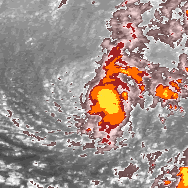
I'm not very confident with my classification as #shear!
Posted
-
by
bretarn
translator
When you look at storm page , you can see it's evolution from shear to eye. Following image of these 6 shaped as first tutorial image as eye
Posted
-
by
Struck
moderator, translator
Hi bretarn, a good task for us as civil scientist to find the solution for your question. I think,a clear classification is difficult here.
Posted
-
by
Struck
moderator, translator
Personally I would always use the notes about shear-storm from the 'Help-Page' from the category 'Shear'.
Posted
-
by
Struck
moderator, translator
A shear-storm should have:
a)Center of gray swirl is closer to the colored clouds
b)The cold area has a tight swirl itself and is organizedPosted
-
by
Struck
moderator, translator
So I create a wind-route pic for possible wind routes for this storm:

Posted
-
by
Struck
moderator, translator
In the W we can see a white/gray #swirl, which an #anti-clockwise wind-route. The center of grey swirl is in the NW of the storm-center.
Posted
-
by
Struck
moderator, translator
But one feature makes me think about our shear theory, because of aspect a) of the argumentation for shear-storms. Personally I can not see,
Posted
-
by
Struck
moderator, translator
that the center of the swirl is closer to colored clouds or the distance between every coloured area is not very small, beginning from NW.
Posted
-
by
Struck
moderator, translator
Maybe possible could be an #embedded-center, but what do you and other civil scientist think about this storm-image. Great pic, bretarn. = )
Posted
-
by
shocko61
Hi Struck ,Hi bretarn ,I would give it one more shot at Embedded when I first had this type of formation I would go with shear but after
Posted
-
by
shocko61
a few times like that ,I found that the storm would redevelop into embedded and some times into an eye, so I like now to have shear storms
Posted
-
by
shocko61
with at least a close margin to the edge of the pink-gray and gray swirl showing that there is a cold front taking the warmer air away .Ian
Posted
-
by
bretarn
translator
Thanks for your analysis , helps me a lot to have better understanding, roughly it was my way of thinking
Posted
-
by
bretarn
translator
but my english language need some improvement to tell it properly. these kind of images, sitting between shear and embedded
Posted
-
by
bretarn
translator
gives quite a challenge to be classified . Jean-Maurice
Posted
-
by
cch001
scientist
I would go #shear here. By the way, tropical cyclones do not have cold or warm fronts. They exist in nearly uniform air masses
Posted
-
by
shocko61
Hi cch001, Hi bretarn , Hi Struck, a good day to you all , My mistake cchoo1 , I thought that to shear the storm was deadened by a cold
Posted
-
by
shocko61
front , as the weather bureau sometimes says the cyclone has lost intensity due to a clod front ?? Please set me right . ???
Posted
-
by
bretarn
translator
I read article in french edition of Scientific American, explaining how cyclones are fueld by warm sea waters,
Posted
-
by
bretarn
translator
and loose their strength passing over colder waters or simply when they land and consequently energy fueled by warm water is lost.
Posted
-
by
shocko61
Hi bretarn , thank you very much ,it is cold and warm water not air . Ian shocko61
Posted
-
by
cch001
scientist
Shear is just winds going different directions or speeds at different heights. A TC can develop a cold front, but when it does it is no
Posted
-
by
cch001
scientist
longer a TC by definition - it is post- or extra-tropical
Posted
-
by
shocko61
Hi cch001 , Thank you for the information I will remember that .Ah I see the light . Ian shocko61 :=)
Posted