Questions for FAQ
-
 by
carl_schreck
scientist
by
carl_schreck
scientist
We'd like to put together and FAQ to post on the website and/or the blog. What are some questions that you've been having about the project, the site, or how to classify the storms? Esp. think of things that would've helped when you were first starting out. We'll try to answer them here, and also post them to the FAQ.
Thanks!
Posted
-
 by
rocketdriver
by
rocketdriver
- I find it hard to find how / where to rea AND make posts such as this .... and to look up old posts for the answers already on line .....
also, 2
how do you back track ... say you realise that you should have classified as "shear" when you had already clicked continue having mistakenly said "embedded" for instance. Would like to be able to back track to correct the mistake before moving on to the next image in the series for that storm .... - why do I have to log in again to post / read posts when I am already logged on on the classification site?
Posted
- I find it hard to find how / where to rea AND make posts such as this .... and to look up old posts for the answers already on line .....
-
by
carl_schreck
scientist
Thanks rocketdriver, those are great comments.
-
Searching... If you mouse over "home", then a link to "Search" appears below it. Perhaps not as intuitive as it could be... There are also the trending keywords on the main page that could help you find posts.
-
Backing up... There is an orange arrow next the "Detailed Classification" check box. If you click that, you can restart the current image. It's admittedly a little hidden. But just like they tell you with tests, don't be afraid to go with your first thought.
-
I think the sites use different sets of cookies. But I'll definitely pass this along to our developers.
Thanks again, and keep 'em coming!
Posted
-
-
by
Struck
moderator, translator
Hi carl_schreck,
maybe this FAQ example could help in addition to this:
Question (Q): How can I save a storm image?
Answer (A): After the classification of a storm set (six images), you can save your favorite picture/s by clicking on the 'Heart-Button' at the end of the classification.Q: Where are my favorite images?
A: Your favorite images were saved and can be shown in your 'Profile-Site' in Cyclone-Center.Q: I am not sure, which type of storm (embedded-center, shear-storm, curved-band etc.) should I choose?
A: In the classification in CycloneCenter, there are many cases, where it could be very difficult to classify a storm-type cleary.
You should follow your feelings for each image.
The 'Question-Button (?)' in each category gives you a few examples and argumentation points to choose the right one.
At the end of the classification you can save your questionable image and you can discuss this image in the 'Cyclone Center board' by clicking on the 'Discuss-Button' in your 'Profile-Site'.Q: I think, I have choose the false selection/option in an image.
A: Don't worry. Each storm image could be classify in an other way by focusing on different features and elements (form, temperature-areas etc.) of a storm-image.
The intention of Cyclone-Center is to collect many opinions and classifications about these storm-images to get a possible final result about a storm image. So each classification is very helpful and could be a piece to reach the intention of Cyclone-Center.Q: In the 'Cyclone-Center-Board' I would like to upload a few storm images into the topic. How could I make this?
A: With a 'right-click' on a storm image, you can choose in the menu the option 'Copy the graphic adress' or like something else.
Now you have saved the direct URL for your image.
With the 'Picture-Button' [CTRL+P] in the Board and in your textbody, you can put the URL into the box and the image can be shown in your topic.Q: What can I do in the board of Cyclone-Center?
A: In the board or talking page of Cyclone-Center, you can discuss your images with other members or with the team/experts of this project.
Additonally you can start a 'Help-Thread' to put your questions about the project into the topic.
Also a talk and a discussion with a 'Science-Thread' is possible, too, to learn more about storms and to exchange experiences about this topic with other members.
By using the board you will get many tips and examples of storm-types, which could be very helpful in your classifications.Q: Is Cyclone-Center for free by using the page?
A: All the features and elements of Cyclone-Center are free.Q: I would like to discuss about an image, but I forgot to save the image.
A: In this case one way could help you. In your 'Profile-Page' you can see a world map. On this map there are few blue circles, which stands for a storm-location, that you have classified recently.
By clicking on a blue circle, a pop-up shows you the option 'Discuss on Talk'.
On this page, you can click 'view storm page' to get the collection of the storm.
If you have found the right image, you can click on it and can start a discussion with the text-body under the image.Posted
-
by
peterthorne
moderator
One that I have come across quite often, particularly with limb imagery is that the storm is disproportionately large in the field of view such that you can tell its either #embedded-center or #curved-band but the subsequent question as to the magnitude of the spiral banding cannot be accurately ascertained.
Posted
-
by
carl_schreck
scientist
Struck, thanks! Those are great suggestions. We appreciate all the work you're putting into this!
Posted
-
by
Casna51
Sometimes it's assumed that participants in a site like this are computer savvy. I joined this site because I'm fascinated by weather, not computers. This is the first site in which I've had the courage to use 'chat' rooms. Struck has been so helpful in getting me through these stages. But it would be helpful to include some of these very basic 'getting around' and 'how to use ' concepts in FAQ, especially since each site seems to have a different format.
Posted
-
 by
jjrennie
moderator
by
jjrennie
moderator
Hi casna!
Great to hear you are making good use of our talk! The goal is to make the whole process as easy and streamlined as we can make it. We hope the FAQ helps a lot!
Posted
-
by
tpatch
In the stats, what is the significance between highest windspeed and lowest pressure relative to the eye in eye storms? Often in my classification, the last image or two shows an eye storm (strongest type?) yet moving along its speed/pressure graph shows highest windspeed and lowest pressure in the middle of the storm track. Why is this? Are the 6 images sequential?If so, shouldn't I be seeing highest speed/lowest pressure about the location of a developed eye?
Posted
-
by
carl_schreck
scientist
tpatch,
Great observations! The 6 images are sequential, but they're chosen at random from the storm's lifetime. So you might not see the beginning or the end of it's life.
And you're right, storms are strongest when they have an eye.
Posted
-
by
carl_schreck
scientist
Thank you all for your questions and suggestions so far. Here is what we've put together so far:
http://blog.cyclonecenter.org/2012/12/14/frequently-asked-questions/Feel free to keep posting questions to this thread and we'll add them to the list.
Posted
-
by
carhogg
I would like to talk to the scientist behind this project to understand better what they are finding out from the project. Where can I post my questions or hear them discuss the project?
Posted
-
by
peterthorne
moderator
Hi there carhogg, the science team have just received their first batch of data where they have a significant number of classifications for each image in the given storms. Its early days in looking at these. The good news is that it seems we have some really good classifiers out there.
As to what we are trying to get out of the project as a whole its a set of consistently analyzed intensity estimates with some uncertainty estimates as a way to better understand past cyclone behavior globally. The science team regularly dip in here and can answer questions, or you could head over to the blog and look at (and comment on) the posts there. If you have specific questions you can raise new messages in the appropriate forum. I hope this helps.
Posted
-
by
cch001
scientist
carhogg, you can message me privately if you like with your questions/comments, or I can answer them here. Thanks!
-ChrisPosted
-
by
csummers1
I am purely guessing on 3 of the questions. (center of storm and the banding questions). I've been on cyclone center almost a year, but still have not been able to figure this out especially on a curved band storm where there is no center. and banding?
Posted
-
by
Struck
moderator, translator
in response to csummers1's comment.
I wish you, csummers1, a relaxed sunday,
thank you for your question.
You are right, that many #curved-band storms are difficult to determine their storm-center.
By answering this question, personally I follow the pink or grey cloud structures around the main-storm, to find a way to a storm-center.But sometimes, a storm-picture could has more than one storm-center.
If you can't answer these questions (storm-center or banding colour etc.), you can publish your storm-picture here, so that we can discuss about your picture on a clearly way.
Once the talk-board will have many difficult storm-pictures or many #curved-band storms, all members will have a large selection of examples to classify these storms much easier. =)Posted
-
by
cch001
scientist
Hello csummers1, Struck makes a good suggestion - if you post the images for which you have questions the community can help you out. There is some guidance on the right hand side about finding the center of a curved band storm when you select the curved band pattern. If you want more details let me know and I can try to help you.
All of the questions posed to you are subjective so don't worry if you do not think you are "right". The advantage of an approach like this (where many people see the same image) is that the right answer will probably surface in the end. -Chris
Posted
-
by
Milt
The segment in the tutorial dealing with "Coldest Surrounding Thick Band Of Clouds" is unclear. I'm not sure what I should be looking for.
Posted
-
by
peterthorne
moderator
Milt,
firstly thanks for classifying.
I am assuming here that this is the tutorial relating to an #eye-storm in which case what we are looking for here is the coldest band of color that completely surrounds the eye. For example in the image below the coldest surrounding thick band of clouds is the middle hue of the blues and it is that color that should be selected. The darker hue does not completely form an enclosed band.
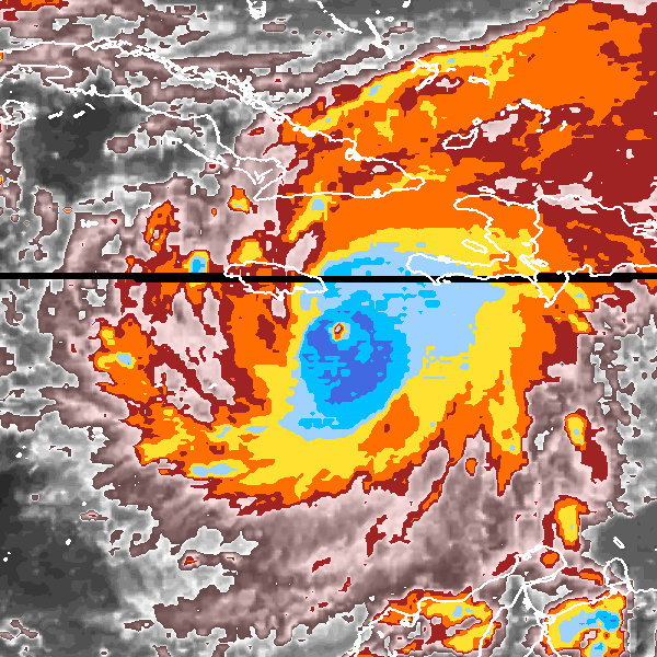
Posted
-
by
MegF
I clicked on a storm for the strongest one but it keeps showing me the other image for the next sequence. Why does that happen?
Posted
-
by
Struck
moderator, translator
in response to MegF's comment.
Hi MegF,
welcome to CycloneCenter. 😉
The classification element to find the strongest storm is only a classification element to make a comparison between two storm images.
By choosing a picture for the strongest one, you determine the status / the development level of the right storm picture in compare to an other image from thr same storm.
The right storm picture is always the picture, which will be classified in a session.
I hope, I could help you.
Posted
-
by
volunteerguy
So far, I've only gotten storms in the pacific. Is there a reason for this? (Not that I don't like the Pacific.)
Posted
-
by
cch001
scientist
Hi,
The storms shown to you are chosen at random. The Pacific is the most populous basin for storms so you are more likely to get one there. Keep at it and you will start seeing storms in other basins. Thanks for contributing! -ChrisPosted
-
 by
DZM
admin
by
DZM
admin
Also, welcome to the project, @volunteerguy ; thanks for being here! 😃
Posted
-
by
Helenmaxwell
I would love to take part in this but I can't get pat the initial screen on my iPad! Does it have to be on computer? Some of the other projects work. It would be helpful to know if they are iPad friendly before you sign up!
Posted
-
by
Knappster
scientist
Hi
I think it should be able to work on an iPad, but will ask the developers.
ThanksPosted
-
by
DZM
admin
in response to Helenmaxwell's comment.
Hi @Helenmaxwell -- iPads are tricky, but the project SHOULD work on one.
Do you have any more luck if you just go straight to the interface? Try: http://www.cyclonecenter.org/#/classify
Let us know if that works out any better. Thank you!!!
Posted
-
Is the Cyclonecenter project compatible with IOS 8? I've tried to work on the project, but after the first set of images (Which storm is stronger?), the Continue button does not work.
Posted
-
by
peterthorne
moderator
Thanks for letting us know. I suspect it may be less the OS and more which browser and browser version but hopefully DZM can help dig further on this. If you can let us know the browser and browser version that may help the technical team resolve.
Posted
-
by
DZM
admin
in response to stevemiller99's comment.
Are you selecting both the type of storm and also the image that most resembles the storm?
I was having that issue earlier today because I forgot that you also need to select the "most looks like" image, not just the type of storm.
Posted
-
by
Irukandji37
The several times so far that I have tried to select the storm on the left, I got the one on the right for categorization anyways. Is this something I can fix or is there a glitch? I'm using Chrome on a desktop.
Posted
-
by
stevemiller99
in response to peterthorne's comment.
I'm using Safari and IOS 8.3. Safari updates as part of IOS. I've had trouble with only one other Zooniverse project and most seem to work well. This particular hiccup seems to focus on the CONTINUE button once the type of storm is selected. I suspect the code for that object needs to be looked at. I've also tried Chrome and had the same results. Thanks
Posted
-
by
peterthorne
moderator
in response to Irukandji37's comment.
lrukandji37,
both you and the process are doing correct thing here. The target image to classify is always the right hand one. If the image 24 hours prior has been classified this shows on left. The question which is stronger is a part of the classification that is also used in operational Dvorak in centers around the world. but you will always proceed to look at the right hand one. Perhaps given the propensity for this to cause understandable confusion some text could / should be added.
Posted
-
by
peterthorne
moderator
in response to stevemiller99's comment.
Thanks. I'll ask the tech folks to take a look.
Posted
-
by
Knappster
scientist
@stevemiller99 - Thanks for letting us know! We will be looking into this.
Posted
-
by
kiershorey
Hello CC people!
I'm a radio presenter in Far North Queensland (think Yasi) who'd love to do an interview with someone regarding the project.
I reckon there'd be many of us up here who'd be keen to get involved.
My email address is:shorey.kier@abc.net.au
If someone could drop me a line when convenient, that'd be super.
Cheers!
KierPosted
-
by
Knappster
scientist
Everybody--
For those interested, here's the interview that Dr. Hennon gave. A great chance to learn about our project.
https://soundcloud.com/abcfarnorth/help-unravel-the-mysteries-of-cyclonesPosted
-
by
DZM
admin
in response to Knappster's comment.
Thanks for sharing, @Knappster --!! Awesome!
Posted
-
by
ergoodall
I am not sure, which type of storm (embedded-center, shear-storm, curved-band etc.) should I choose? A: In the classification in CycloneCenter, there are many cases, where it could be very difficult to classify a storm-type cleary. You should follow your feelings for each image. The 'Question-Button (?)' in each category gives you a few examples and argumentation points to choose the right one. At the end of the classification you can save your questionable image and you can discuss this image in the 'Cyclone Center board' by clicking on the 'Discuss-Button' in your 'Profile-Site'.
Storm type is the first question I am asked on the first storm image I've been presented. Although the types Embedded-Center, Shear-Storm, Curved-Band and Other are provided as choices, there wasn't any definition of these types or presentation. You can say "follow your feelings" but without minimum background training or even definition of terms, any choice I make will simply be a random string choice. This makes me doubt the value of my contribution and reduces my willingness to even participate in your project. If you're not going give me minimal information necessary to use judgement in evaluating your images, I don't see why I should spend the time.
Posted
-
by
peterthorne
moderator
in response to ergoodall's comment.
ergoodall,
there should be substantive guidance available to support. I suspect that there may be some compatibility issue with your browser or platform. If you let us know we can look further.
Posted
-
by
cch001
scientist
ergoodall, there are a series of links just below the images that you will find useful:
"Site Intro" gives you some quick information about the whole point of the project and the mechanics of it "Tutorial" will take you through a real image and provide extensive explanations along the way "Guide" will take you to some helpful information about the question that is currently being asked of you
If you still have questions I am happy to answer them. -Chris
Posted
-
by
Knappster
scientist
Also, we recently added a tutorial page to our blog site at:
http://blog.cyclonecenter.org/tutorials/Posted
-
What do you do when there are two or more eye walls?
Posted
-
by
peterthorne
moderator
Do you have the example? In general this will be an eye-wall replacement cycle. Personally I would make a judgement which one was dominant and give the eye size and surrounding color based upon that. If you want to play safe it is probably most correct to base on the outer eye which is to become the dominant eye feature (the inner eye is decaying) but very very early on the inner eye may be the appropriate feature. That's my opinion but science team will likely be along shortly to point out how wrong I am. Paging @cch001 + @Knappster ... anyone there?
Posted
-
Hello to everyone,
Just signed up. Was looking for data pertaining to hurricanes that have hit South Central Louisiana (Vermillion Bay area). WU site has great track data going back to the 1850's but I was looking for some more specific data - like wind speeds at landfall or maybe inland a bit. This is probably a tall order, but I figured if I could find a place that could point me in the right direction this would be the place to ask.
Thank you ahead of time.
StormDodgerDudePosted
-
by
cch001
scientist
in response to StormDodgerDude's comment.
Hi StormDodgerDude,
Thanks for signing up! You might want to try contacting Chris Landsea, the Science and Operations Officer at the National Hurricane Center. He has been leading a team of people who have been looking at historical hurricane data and may be able to give you some ideas on how to proceed. In the meantime, if you have any questions about the Cyclone Center project or classifications, please let us know.
Chris
Posted
-
by
gbeerjohn
I just got onto this site (from another Zooniverse project I spent a lot of time on). I do not feel qualified to help classify based just on the tutorial provided.
- IWhen the "This or That" part of the tutorial that quickly makes a choice from 3 or 4, whatever it is, images, am I supposed to be learning from the images? It is going much, MUCH, too fast for me to even begin comparing the choices, if that's what I'm supposed to be learning from.
- I see references to my being able to identify colder from warmer clouds, but I don't see anything telling me how to read what is warm and what is cold. A gradiated key would be helpful. Maybe I'm just not finding it.
Thanks.
Posted
-
by
peterthorne
moderator
Hi gbeerjohn,
Thanks for coming by. I hope that I can help and that you can then feel confident to have a go.
On #1 the images are good clear examples of storm types. The idea is to select the closest analogue to the image you are being asked to classify from the set of examples. You can do this by selecting a storm type and then image type. You can flip between storm types before making your selection. Often the image will be ambiguous. Go with your best guess. We get multiple classifications of each image to understand the uncertainty in the classification and your view is valuable.
On #2 the cloud temperature is denoted by the colour. Greys, reds, oranges and yellows are warmer while blues and whites are colder. Cloud temperature is related to cloud height so with the blues and whites you are seeing the really cold and deep clouds. In eye storms the grey centre is where the eye is and there are no / very few clouds.
Hope the above helps
Posted